Midland Rail Cycle Trail
To create a Cycleway from Christchurch to Arthurs pass
with side branches to Castle Hill Village and Porters Alpine resort
Brief overview
in 2009 After John Key’s job summit and talk about Rail trails I started getting excited hoping our area could create a cycle way like the Otago Rail trail I cycled with 2 families in 2006
I was not alone as others were working on a similar plan which resulted in a plan drawn up by Environment Canterbury with input of then Selwyn Councillor John Morton and others.
In February 2010 decisions were made on which tracks were successful, however ours lost out.
In 2018 the idea was revived in the hope of getting funding from the Tourism Infrastructure fund with again no success. (Tourism infrastructure fund Mountain to Sea TIF Application and Appendix)
In 2020 letters were sent out to Govt Ministers with the hope of getting funding for a trail but were met with a negative answer we also submitted to Council for inclusion into their Draft Annual Plan
With a great gap in the NZ Cycle Trails map the time is now to start planning and creating the next NZ cycle trial.
This trail in its infancy can cater for the strong riders (grade 3) with a Springfield to Cass trail, progress to the next level incorporating Castle Hill Village and finish with the final plan of a deluxe train ride to Arthurs Pass and cycle back at a leisurely pace back to Christchurch
Proposal STAGES BY TIMELINE
2023
· complete feasibility study and budget
· set up a Charitable Non-Profit Organisation
· get permission from relevant authorities
· get permission from relevant landowners
2024
· find funding
· complete talks with govt dept’s and secure approvals
· Commence and complete stage 1 Springfield to Cass
2025
· start planning stage 2 Avoca station to Castle Hill and look at Porter Alpine Resort route
2026
· start planning stage 3 Cass to Arthurs Pass
2027
· start planning stage 4 Christchurch to Springfield
feasability study requirements
The feasibility study will look at the issues identified below and recommend the best option for addressing the issue to enable the Cycleway to be progressed.
Some of these issues include:
- Confirming a route is realistically achievable.
-
(1) Landowners and stakeholder’s permissions
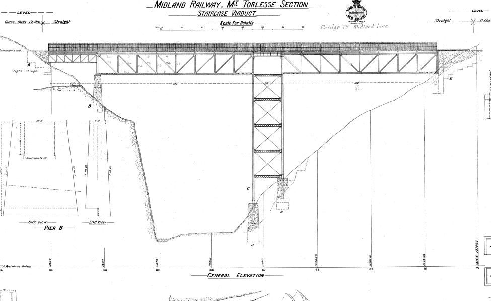
(2) Getting across Staircase (either by viaduct, clip on or bride at the bottom)
(3) Getting across Broken River (either at broken river viaduct or Avoca homestead foot bridge)
(4) Getting past slips and narrow sections between 70 and 71km mark
(5) Getting across Paterson Stream
- Set up a Charitable non-profit entity
- - Resource Consents for earthworks associated with trail construction.
- - Approach to Staircase Gully Railway Bridge may require various constraints as this could affect the visual character of the bluffs that lead into this location.
- - Kiwi Rail agreement for access along, adjacent and across the required locations.
- - This includes approval for using the underside or railway corridor of the Staircase Gully Railway Bridge
- . - Land easements for the trail to cross private and crown land. - Alignment to other planned cycleway connections.
- Buy in from all relevant Authorities with control over various sections of the trail
2009 PROPOSAL FOR THE ROUTE ARTHURS PASS TO CHRISTCHURCH
(Extracts from Southern alpine pacific cycle trail concept proposal 2009 - Environment Canterbury)
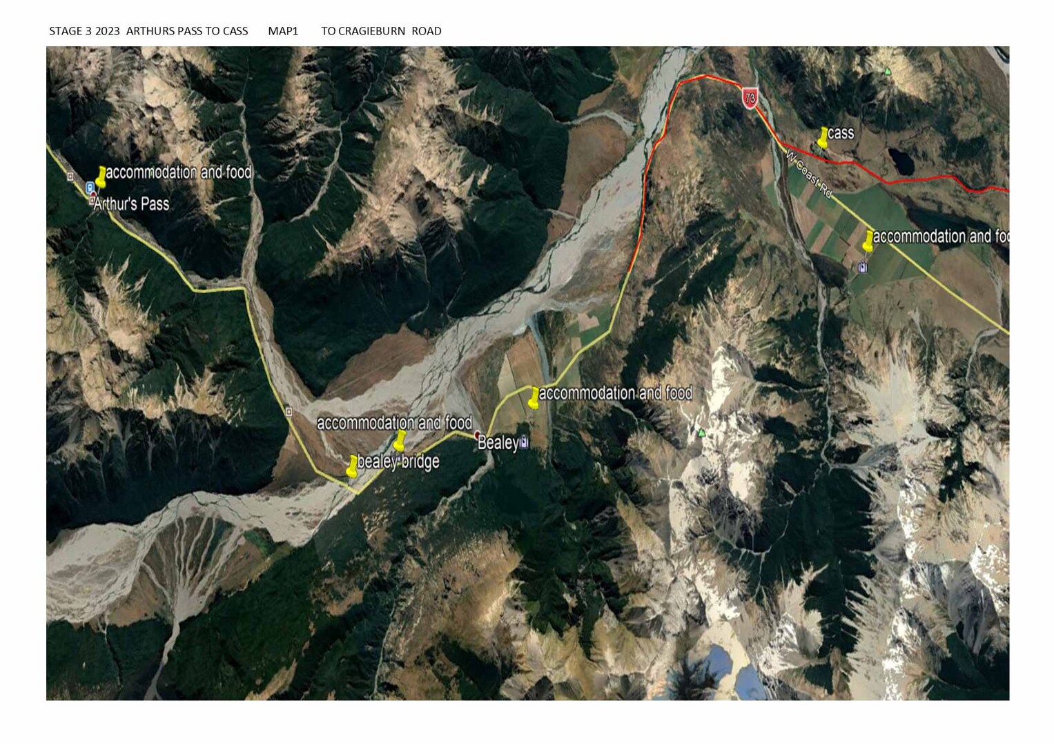
The cycleway will start on a new track to be formed adjacent to the Arthur’s Pass railway station alongside the Bealey River. For some 4 km cyclists will enjoy alpine views until they cross the Bealey River by way of a clip-on cycleway attached to the railway bridge.
Cyclists will then make use of new and existing tracks on the true left of the Waimakariri River, which will hug the native forest cloaked lower contours of a series of peaks. This track will join with Riversdale Road, passing Paterson Lodge and then head south to the Mount White Bridge crossing over the Waimakariri River, where it will re-join a new track adjacent to the railway line, connecting to existing track alongside Grasmere Stream and arriving in Cass.
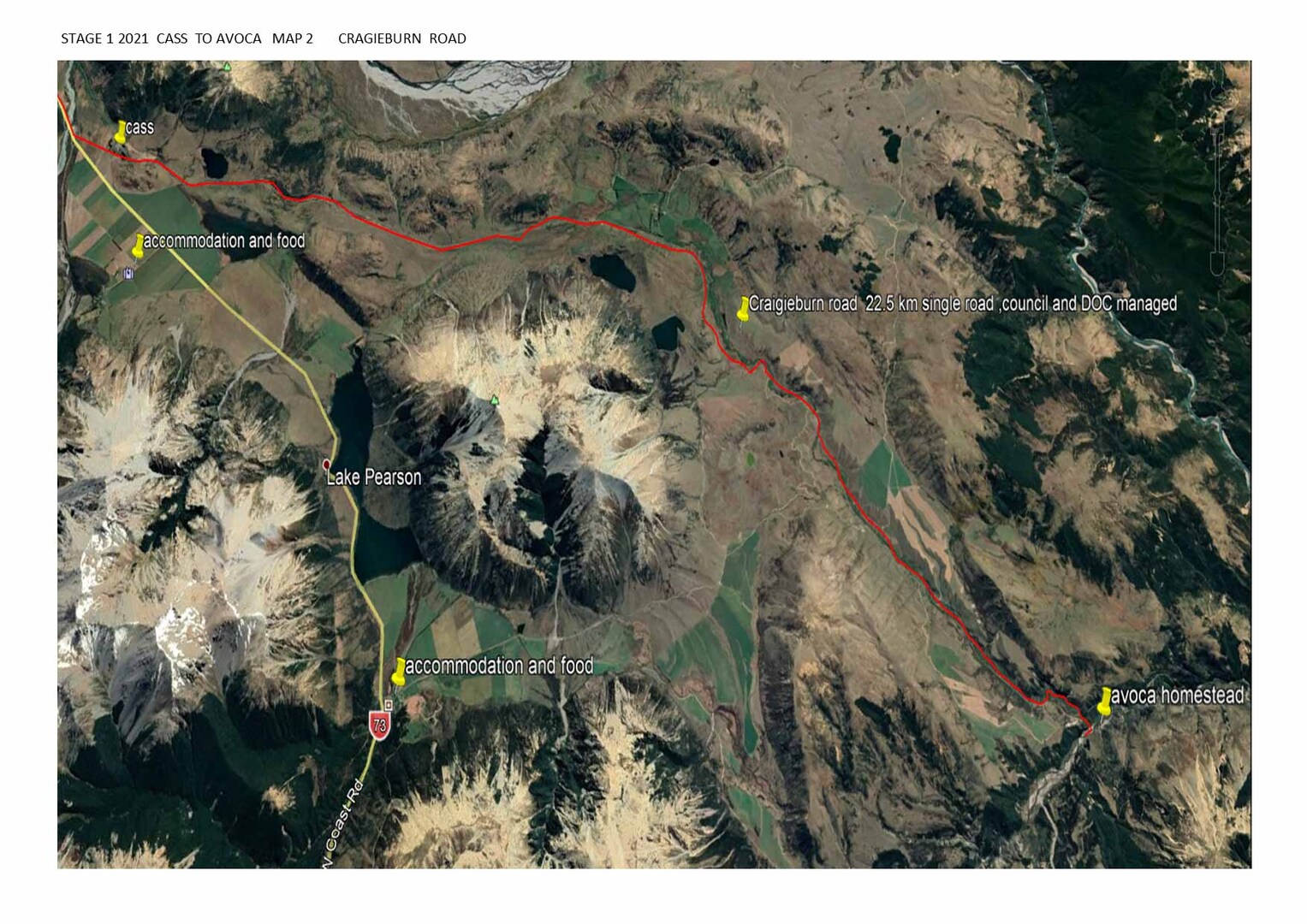
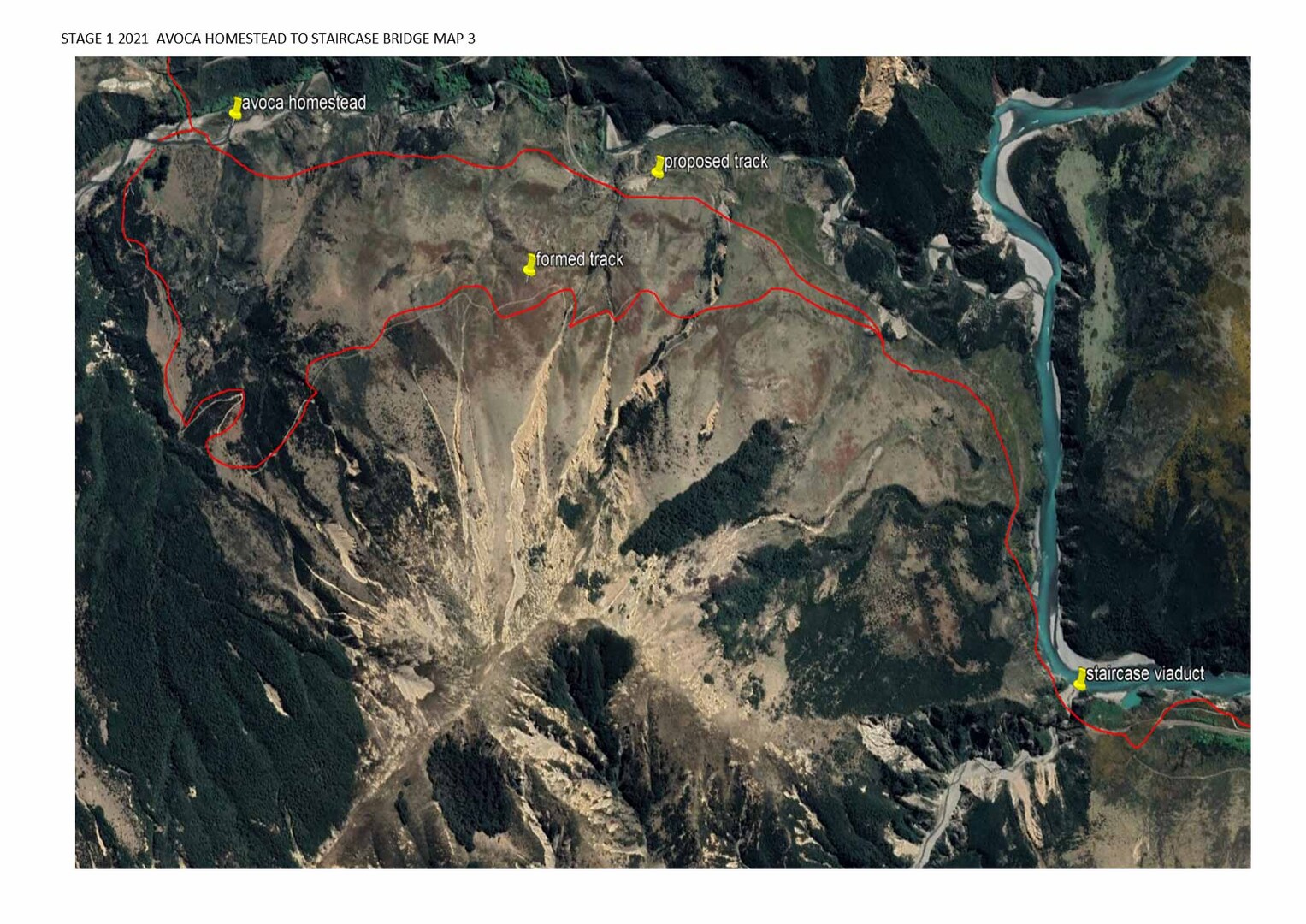
Cyclists have travelled some 22 km and descended some 160 metres. Leaving Cass, cyclists follow an existing track until they reach a railway crossing at Craigieburn Road. Cyclists will then follow this low volume scenic road and a subsequent track adjacent to Slovens Stream for some 18 km, until they reach Avoca at Broken River. At the confluence of Slovens Stream and Broken River, cyclists cross a swing bridge leading to the historic Avoca Homestead, joining existing track leading away from the river and into the Korowai Torlesse Tussocklands Park. This section leads to Staircase Gully, some 5 km to the southeast, and offers spectacular views to the southern alps, with occasional glimpses of the Waimakariri River as it meanders south.
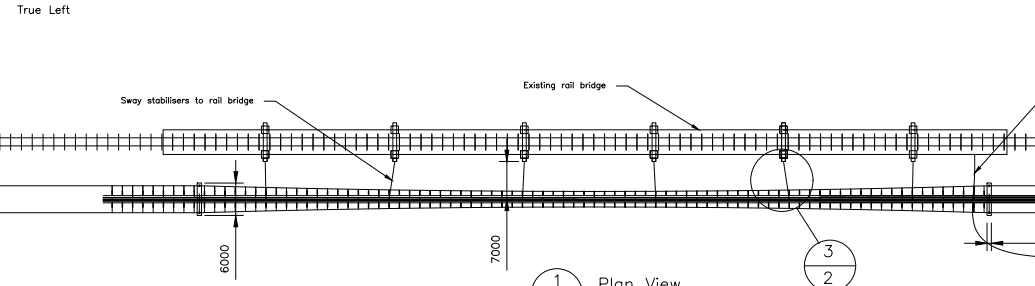
At 1 km or so north of Staircase Gully, the track will cross the railway line and follow a new track with views down into the river. A cycleway structure will be provided around the bluffs on the approach to Staircase gully railway bridge, which will link into the decked-out underside of the bridge structure, where cyclists will cross the Gully that runs some 80 metres below.
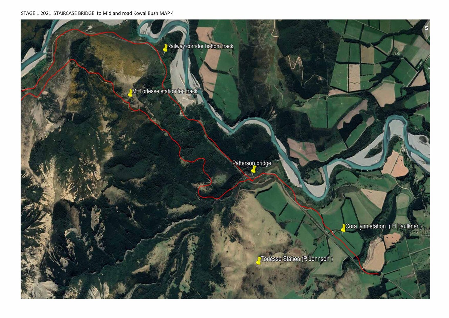
Cyclists then rejoin existing track, to the true right of the Waimakariri River and follow this track for some 6 km all the way to Pattersons Stream, via native bush track. A swing bridge is to be provided across the stream close to its convergence with the Waimakariri River at Otarama. Cyclists then follow existing track, crossing the railway and then Joyces Stream, linking with Midland Road. For some 15 km cyclists then follow quiet scenic roads, coming within proximity to the Springfield township. Taking Frasers Road, Wrights Road and Woodlands Road, cyclists come close to the Sheffield township and a short distance further, the Waimakariri Gorge Bridge. They have now ridden 85 km and descended some 500 metres from Arthur’s pass
2020 updated plan (THE PRAGMATIC APPROACH)
The Trail like the original 2009 proposal starts in Arthurs Pass but in the first 2 years will follow the road to concentrate on the more difficult Stage 1 (43 km Cass to Springfield) and 2(Avoca Homestead to Castle Hill).
With the Limited traffic on the Craigieburn Road(22km), it is envisioned that the current road can be made to a sufficient standard for both cyclist and vehicles to ride on and pass safely, it is like the current A2O leg from Rotten Tommy to Pukaki. Once it reaches Slovens Stream it needs to hug the railway corridor for 400m until it can go down to Broken River, road build/upgrade is required for 450 m to mitigate the flooding by the Willow trees alternatively is to look at the top terrace via Petticoat Junction to Broken River Viaduct.
The Avoca Homestead bridge needs to have an upgrade or replacement, Avoca is the Junction between stage 1 and 2 with Stage 1 continuing on either a challenging uphill ride on the existing 4wd track (similar to Ohau Lodge to Quailburn Woolshed leg) or ride the new level family orientated track to Staircase Gully where the 4wd track joins the easy track again at staircase.
Crossing Staircase Gully can be done by a purpose build Suspension Bridge to the Springfield side, or a track down to the river and up again like the Canmuir Ladder on the Dunstan Trail from there we can access the dirt track from the railway corridor and make our way to the midland road enjoying spectacular river views or if no permission is achieved the top track on Mt Torlesse Station Land and then traversing to Cora lynn station for the final leg to Springfield via Kowai road .
Once we turn onto Pocock’s Road we will then turn right and divert from the original plan and travel via the local towns with their cafés and accommodation providers and join the Council proposed Cycle trials as outlined in the Council’s Walking and Cycling Strategy 2018.
Stage 2 (17km) is the Leg between Avoca Homestead and Castle hill across the DOC estate, this is a family style track of around 10 km which will enhance the current trails available at Castle Hill and the Craigieburn trails cementing the Alpine Village as a premier destination. possible further trails can be created to the 2010 Porter Ski Area Village Proposal along the Porter River.
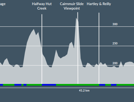
Stage 3 (24 km) Cass to Arthurs Pass will be of Benefit to both motorist and cyclist alike as the road is very narrow in places and the ability to give cyclist who are travelling New Zealand the quiet enjoyment and Safety of their own track like the parts along Highway 8 and 83
Stage 4 (59 km) is a combination of Council proposed routes to link in the plains to the City and Airport.
Suspension bridge proposal (click on image to enlarge)
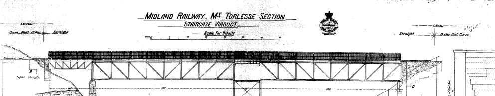
Staircase Viaduct (click on image to enlarge)
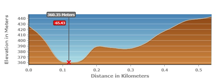
CANMUIR COMPARISON TO STAIRCASE CREEK IF bridge option is not possible